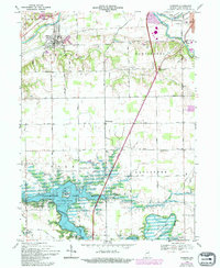
1969 Map of Andrews
USGS Topo · Published 1994About this map
Andrews sits at the northern edge of this landscape, positioned along the Norfolk and Western rail corridor and the broad valley of the Wabash River. The terrain transitions from the industrial and transport hub in the north to the extensive waters of Salamonie Lake in the south, a reservoir that reshaped the local geography. The map reveals a dense network of rural infrastructure, including Township Sch and numerous faith-based landmarks such as Pleasant Grove Ch and Pilcher Chapel. Of particular interest to genealogists are the dispersed burial grounds like Riverside Cem and the German Settlement Cem, which point to the diverse heritage of the early settlers in Dallas and Lancaster townships. The southern reaches are defined by the Salamonie River as it winds through Heineys Bend, past the Mount Etna Public Use Area and the small settlement of Mt Etna.
Find a feature on this map
43 named features on this map. Tap any name to fly to it.
Don’t see what you’re looking for? This feature index may not catch every label — zoom into the map to look around manually.
Map Details
Editions of this 1969 Andrews Map
3 editions found
Other maps of this area

1950 · Lagro
USGS Topo · 1:24,000

1950 · Andrews
USGS Topo · 1:24,000

1950 · Warren
USGS Topo · 1:24,000

1950 · Mount Etna
USGS Topo · 1:24,000

1951 · Mount Etna
USGS Topo · 1:24,000

1951 · Andrews
USGS Topo · 1:24,000

1951 · Lagro
USGS Topo · 1:24,000

1952 · Warren
USGS Topo · 1:24,000

1952 · Majenica
USGS Topo · 1:24,000

1953 · La Fontaine
USGS Topo · 1:24,000