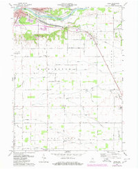
1972 Map of Anoka
USGS Topo · Published 1980About this map
The Wabash River carves the northern landscape of this region, shaping distinctive landmarks like Kienly Island and Biddle Island as it flows past the southeastern edge of Logansport. This 1970s record illustrates a transition between the urban sprawl of the city and the grid-aligned agricultural tracts of Washington and Deer Creek townships. The local infrastructure is anchored by the Conrail line and the Logansport Municipal Airport, which serve the small communities and rural intersections.
Find a feature on this map
49 named features on this map. Tap any name to fly to it.
Don’t see what you’re looking for? This feature index may not catch every label — zoom into the map to look around manually.
Map Details
Editions of this 1972 Anoka Map
Other maps of this area

1951 · Onward
USGS Topo · 1:24,000

1951 · Twelve Mile
USGS Topo · 1:24,000

1953 · Danville
USGS Topo · 1:250,000

1955 · Danville
USGS Topo · 1:250,000

1955 · Logansport
USGS Topo · 1:24,000

1955 · Anoka
USGS Topo · 1:24,000

1956 · Danville
USGS Topo · 1:250,000

1959 · Galveston
USGS Topo · 1:24,000

1959 · Young America
USGS Topo · 1:24,000

1960 · Lucerne
USGS Topo · 1:24,000