
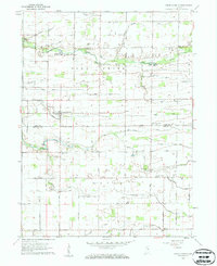
1959 Map of Young America
USGS Topo · Published 1961About this map
The agricultural landscape of north-central Indiana, spanning the border of Cass and Howard Counties, is defined by an intricate network of drainage ditches that supported the region's farming economy in the late 1950s. Deer Creek and Little Deer Creek provide the natural drainage for the area, supplemented by numerous man-made features like Brown Ditch and Henry Gilbert Ditch. This era shows a community rooted in local institutions, from the Ervin Sch to numerous rural houses of worship including Upper Deer Creek Ch and Poplar Grove Ch. Settlement patterns are concentrated at small crossroads such as Young America, Deacon, and Kappa Corner. Near the eastern edge, the Galveston Airport is already noted as abandoned, reflecting shifts in local aviation. Genealogists will find significant value in the mapped family cemeteries, including Hoover-Snider Cem and Pickett Cem, which anchor the rural landscape to its early inhabitants.
Find a feature on this map
54 named features on this map. Tap any name to fly to it.
Don’t see what you’re looking for? This feature index may not catch every label — zoom into the map to look around manually.
Map Details
Editions of this 1959 Young America Map
2 editions found
Other maps of this area

1951 · Onward
USGS Topo · 1:24,000

1953 · Danville
USGS Topo · 1:250,000

1955 · Danville
USGS Topo · 1:250,000

1955 · Anoka
USGS Topo · 1:24,000

1956 · Danville
USGS Topo · 1:250,000

1959 · Galveston
USGS Topo · 1:24,000

1960 · Kokomo West
USGS Topo · 1:24,000

1961 · Russiaville
USGS Topo · 1:24,000

1961 · Burlington
USGS Topo · 1:24,000

1962 · Deer Creek
USGS Topo · 1:24,000