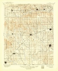
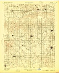
1891 Map of Anthony
USGS Topo · Published 1949About this map
Anthony and Harper anchor this late nineteenth-century landscape, a period when the grid of Kansas townships was being actively stitched together by competing rail lines. The Atchison Topeka and Santa Fe Railroad and the Missouri Pacific Railroad define the movement of goods and people between frontier settlements like Attica, Hazelton, and New Kiowa. Along the Chikaskia River and the numerous branches of Bluff Creek, the terrain transitions from the valley flats to prominent high points like Pilot Knob. This survey captures the region just before the turn of the century, showing established towns such as Nashville, Spivey, and Sharon as they developed along the steel arteries. Notable watercourses like the Medicine Lodge River and Sandy Creek indicate the drainage patterns that influenced early town site selection and agricultural development during this era of rapid prairie settlement.
Find a feature on this map
74 named features on this map. Tap any name to fly to it.
Don’t see what you’re looking for? This feature index may not catch every label — zoom into the map to look around manually.
Map Details
Editions of this 1891 Anthony Map
6 editions found
Other maps of this area

1889 · Anthony
USGS Topo · 1:125,000

1889 · Cheney
USGS Topo · 1:125,000

1889 · Caldwell
USGS Topo · 1:125,000

1891 · Medicine Lodge
USGS Topo · 1:125,000

1891 · Cheney
USGS Topo · 1:125,000

1891 · Anthony
USGS Topo · 1:125,000

1892 · Kingman
USGS Topo · 1:125,000

1892 · Pratt
USGS Topo · 1:125,000

1893 · Caldwell
USGS Topo · 1:125,000

1893 · Medicine Lodge
USGS Topo · 1:125,000