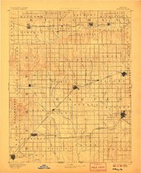
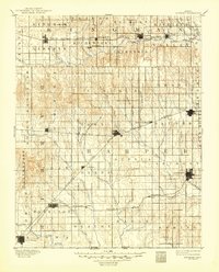
1891 Map of Anthony
USGS Topo · Published 1906About this map
The Medicine Lodge River flows across the southwestern corner of this Kansas landscape, while the Chicaskia River winds through the north. This late nineteenth-century survey reveals a territory organized by township grids and burgeoning rail connections. The Atchison Topeka and Santa Fe Railroad cuts through the heart of the region, linking established towns like Harper and Attica with smaller junctions and stations such as Crisfield and Crystal Springs. In the south, Hazelton and Corwin sit along the Missouri Pacific Railroad, demonstrating how the arrival of steam power transformed the prairie into a network of shipping points. Local topographic features like Pilot Knob stand out against the drainage basins of Bluff Creek and Sandy Creek. The grid of early townships, including Lawn, Sharon, and Ruella, provides a window into the initial cadastral organization of the county before more modern consolidations.
Find a feature on this map
74 named features on this map. Tap any name to fly to it.
Don’t see what you’re looking for? This feature index may not catch every label — zoom into the map to look around manually.
Map Details
Editions of this 1891 Anthony Map
6 editions found
Other maps of this area

1889 · Anthony
USGS Topo · 1:125,000

1889 · Cheney
USGS Topo · 1:125,000

1889 · Caldwell
USGS Topo · 1:125,000

1891 · Medicine Lodge
USGS Topo · 1:125,000

1891 · Cheney
USGS Topo · 1:125,000

1891 · Anthony
USGS Topo · 1:125,000

1892 · Kingman
USGS Topo · 1:125,000

1892 · Pratt
USGS Topo · 1:125,000

1893 · Caldwell
USGS Topo · 1:125,000

1893 · Medicine Lodge
USGS Topo · 1:125,000