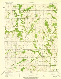
1957 Map of Antioch
USGS Topo · Published 1958About this map
Bull Creek and its many tributaries, including Smith Branch and Tuggle Branch, carve a dense drainage pattern through this corner of the Kansas prairie during the late 1950s. The small settlement of Antioch sits near the northern edge of the survey, anchored by Antioch Ch. The landscape is defined by a traditional rural organization of small townships like McCamish, Gardner, Richland, and Marysville, each supporting a network of local schools. These educational landmarks, such as Union Sch and Poplar Ridge Sch, reveal a decentralized community structure typical of the era before widespread school consolidation. Evidence of local industry and infrastructure appears in the lower half of the map, where a Gaging Station monitors the water levels and early energy extraction is noted at several sites labeled Gas Well and Oil Well.
Find a feature on this map
25 named features on this map. Tap any name to fly to it.
Don’t see what you’re looking for? This feature index may not catch every label — zoom into the map to look around manually.
Map Details
Editions of this 1957 Antioch Map
2 editions found
Other maps of this area

1885 · Lawrence
USGS Topo · 1:125,000

1887 · Olathe
USGS Topo · 1:125,000

1889 · Lawrence
USGS Topo · 1:125,000

1893 · Olathe
USGS Topo · 1:125,000

1947 · Lawrence
USGS Topo · 1:250,000

1950 · Lawrence
USGS Topo · 1:250,000

1956 · Wellsville
USGS Topo · 1:24,000
1956 · Ocheltree
USGS Topo · 1:24,000

1956 · Paola East
USGS Topo · 1:24,000
1956 · Edgerton
USGS Topo · 1:24,000