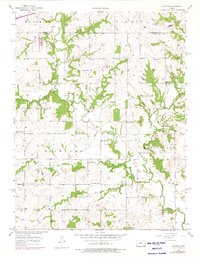
1957 Map of Antioch
USGS Topo · Published 1975About this map
Antioch sits at the heart of this agricultural landscape, straddling the border between Johnson and Miami counties during the late 1950s. The region is defined by a dense network of rural infrastructure, where local life revolved around neighborhood institutions like Union Sch, North Windy Sch, and Richland Sch. The drainage of Bull Creek and its many tributaries, including Smith Branch and Tuggle Branch, dictate the township boundaries of McCamish, Gardner, and Marysville.
Find a feature on this map
26 named features on this map. Tap any name to fly to it.
Don’t see what you’re looking for? This feature index may not catch every label — zoom into the map to look around manually.
Map Details
Editions of this 1957 Antioch Map
2 editions found
Other maps of this area

1885 · Lawrence
USGS Topo · 1:125,000

1887 · Olathe
USGS Topo · 1:125,000

1889 · Lawrence
USGS Topo · 1:125,000

1893 · Olathe
USGS Topo · 1:125,000

1947 · Lawrence
USGS Topo · 1:250,000

1950 · Lawrence
USGS Topo · 1:250,000

1956 · Wellsville
USGS Topo · 1:24,000
1956 · Ocheltree
USGS Topo · 1:24,000

1956 · Paola East
USGS Topo · 1:24,000
1956 · Edgerton
USGS Topo · 1:24,000