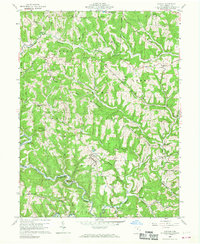
1960 Map of Antioch
USGS Topo · Published 1968About this map
The Little Muskingum River winds through the southern portion of this Monroe County landscape, defining the topography alongside the deeply incised valleys of Dismal Creek and Cranenest Fork. Settlement is concentrated in small upland communities like Antioch, Laings, and Mechanicsburg, where early development followed the high ground of Cranenest Ridge and Jackson Ridge. The map documents a rural Ohio social fabric through its numerous small houses of worship and burial grounds, including Moffets Ch, Fletchers Chapel, and the Norris Cem. Much of the eastern terrain falls within the Wayne National Forest, showing a landscape where public forest land intermingles with private holdings. Genealogists will find particular value in the distribution of family-named cemeteries such as Monahan Cem and Woodfield Cem, which remain as markers of the area's pioneer generations within the Old Seven Ranges.
Find a feature on this map
61 named features on this map. Tap any name to fly to it.
Don’t see what you’re looking for? This feature index may not catch every label — zoom into the map to look around manually.
Map Details
Editions of this 1960 Antioch Map
4 editions found
Other maps of this area

1905 · Clarington
USGS Topo · 1:62,500

1905 · New Matamoras
USGS Topo · 1:62,500

1905 · Woodsfield
USGS Topo · 1:62,500

1906 · New Martinsville
USGS Topo · 1:62,500

1924 · New Martinsville
USGS Topo · 1:62,500

1924 · New Matamoras
USGS Topo · 1:62,500

1926 · New Martinsville
USGS Topo · 1:62,500

1926 · New Matamoras
USGS Topo · 1:62,500

1935 · Clarington
USGS Topo · 1:62,500

1940 · Clarington
USGS Topo · 1:62,500