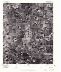
1976 Map of Anton NE
USGS Topo · Published 1978About this map
The agricultural grid of the High Plains dominates this orthophoto map, where the winding course of Blackwater Draw cuts a distinct path through Hale County. Captured in the mid-1970s, the aerial imagery reveals a landscape defined by circular pivot irrigation patterns and vast rectangular fields, showing the intensive land use of the Texas Panhandle. Unlike traditional topographic maps, this orthophotograph provides a direct visual record of the ground surface, highlighting the subtle depressions and drainage patterns of the Llano Estacado. The path of Blackwater Draw serves as the primary geographic landmark in an otherwise uniform expanse of productive farmland, illustrating how natural watercourses influenced the layout of rural property lines and early road systems in this part of Texas.
Find a feature on this map
1 named feature on this map. Tap any name to fly to it.
Don’t see what you’re looking for? This feature index may not catch every label — zoom into the map to look around manually.
Map Details
Editions of this 1976 Anton NE Map
2 editions found
Other maps of this area

1954 · Lubbock
USGS Topo · 1:250,000

1954 · Plainview
USGS Topo · 1:250,000

1954 · Clovis
USGS Topo · 1:250,000

1954 · Brownfield
USGS Topo · 1:250,000

1957 · Anton
USGS Topo · 1:62,500

1957 · Abernathy
USGS Topo · 1:62,500

1958 · Brownfield
USGS Topo · 1:250,000

1958 · Clovis
USGS Topo · 1:250,000

1958 · Plainview
USGS Topo · 1:250,000

1962 · Brownfield
USGS Topo · 1:250,000