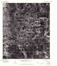
1976 Map of Anton SE
USGS Topo · Published 1978About this map
Agricultural patterns and the distinct circular imprints of center-pivot irrigation dominate this mid-1970s orthophotoquad of the Texas High Plains. The small settlement of Roundup serves as a lone commercial and residential anchor in an landscape otherwise defined by a meticulous grid of large-scale farming and local access roads. Traversing the terrain, a prominent County Line indicates the administrative divide that shapes local governance and land records. The imagery reveals the intensity of cultivation in this region of Lubbock, capturing the exact footprint of fields and homesteads as they existed during a period of significant technological transition in American prairie farming.
Find a feature on this map
2 named features on this map. Tap any name to fly to it.
Don’t see what you’re looking for? This feature index may not catch every label — zoom into the map to look around manually.
Map Details
Editions of this 1976 Anton SE Map
2 editions found
Other maps of this area

1954 · Lubbock
USGS Topo · 1:250,000

1954 · Brownfield
USGS Topo · 1:250,000

1956 · Shallowater
USGS Topo · 1:24,000

1957 · Lubbock
USGS Topo · 1:62,500

1957 · Anton
USGS Topo · 1:62,500

1957 · Abernathy
USGS Topo · 1:62,500

1957 · Wolfforth
USGS Topo · 1:62,500

1958 · Brownfield
USGS Topo · 1:250,000

1962 · Brownfield
USGS Topo · 1:250,000
1976 · Anton SW
USGS Topo · 1:24,000