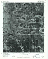
1976 Map of Roundup
USGS Topo · Published 1985About this map
Roundup occupies the lower portion of this 1976 orthophotograph, centered in a landscape defined by high-plains agriculture and the distinct circular patterns of playa lakes. The aerial imagery captures the geometric precision of the South Plains, where square agricultural plots are interrupted only by a prominent County Line and natural depressions that dot the terrain. Unlike a traditional topographic map, this survey provides a direct visual record of land use and vegetation patterns during the mid-1970s, showing the specific layout of farmsteads and transport routes around the settlement of Roundup before subsequent decades of development altered the rural footprint.
Find a feature on this map
2 named features on this map. Tap any name to fly to it.
Don’t see what you’re looking for? This feature index may not catch every label — zoom into the map to look around manually.
Map Details
Editions of this 1976 Roundup Map
2 editions found
Other maps of this area

1954 · Lubbock
USGS Topo · 1:250,000

1954 · Brownfield
USGS Topo · 1:250,000

1956 · Shallowater
USGS Topo · 1:24,000

1957 · Lubbock
USGS Topo · 1:62,500

1957 · Anton
USGS Topo · 1:62,500

1957 · Abernathy
USGS Topo · 1:62,500

1957 · Wolfforth
USGS Topo · 1:62,500

1958 · Brownfield
USGS Topo · 1:250,000

1962 · Brownfield
USGS Topo · 1:250,000
1976 · Anton SW
USGS Topo · 1:24,000