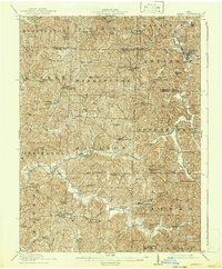
1911 Map of Antrim
USGS Topo · Published 1942About this map
The National Road cuts across the southern portion of this landscape, serving as a primary artery for the region during the early twentieth century. This thoroughfare connects the settlements of Middlebourne, Elizabethtown, Easton, and Washington, illustrating the typical township and village growth patterns found in eastern Ohio. The map reveals an extensive network of rural education and worship, with dozens of local institutions such as the Moccasin School, Sligo School, and Wesley Church scattered throughout the valleys and ridges.
Find a feature on this map
81 named features on this map. Tap any name to fly to it.
Don’t see what you’re looking for? This feature index may not catch every label — zoom into the map to look around manually.
Map Details
Editions of this 1911 Antrim Map
3 editions found
Other maps of this area

1902 · Scio
USGS Topo · 1:62,500

1903 · Flushing
USGS Topo · 1:62,500

1904 · Scio
USGS Topo · 1:62,500

1905 · Woodsfield
USGS Topo · 1:62,500

1905 · Flushing
USGS Topo · 1:62,500

1909 · Antrim
USGS Topo · 1:48,000

1909 · Uhrichsville
USGS Topo · 1:62,500

1909 · Summerfield
USGS Topo · 1:62,500

1909 · Cambridge
USGS Topo · 1:62,500

1911 · Antrim
USGS Topo · 1:62,500