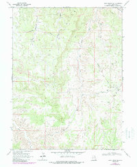
1968 Map of Archy Bench SE
USGS Topo · Published 1987About this map
Rock House Gas Field and the Oil Springs Oil and Gas Field dominate this industrial landscape in eastern Utah, as mapped in the late 1960s and updated in the 1980s. The terrain is characterized by a dense network of energy infrastructure, including numerous Gas Wells, Oil Wells, and a connecting Pipeline system. These industrial features are set against a backdrop of complex drainage systems such as the West Fork Asphalt Wash and Bitter Creek. Scattered evidence of local ranching and early habitation appears in the form of the Seely Cabin, Olsen Corral, and Cedar Corral, providing a glimpse into the human presence amidst the energy-rich badlands of Archy Bench. The presence of a Landing Field and several Storage Bins further highlights the logistical requirements of this remote resource extraction zone during the mid-to-late 20th century.
Find a feature on this map
20 named features on this map. Tap any name to fly to it.
Don’t see what you’re looking for? This feature index may not catch every label — zoom into the map to look around manually.
Map Details
Editions of this 1968 Archy Bench SE Map
2 editions found
Other maps of this area

1885 · East Tavaputs
USGS Topo · 1:250,000

1956 · Grand Junction
USGS Topo · 1:250,000

1959 · Grand Junction
USGS Topo · 1:250,000

1960 · Grand Junction
USGS Topo · 1:250,000

1962 · Grand Junction
USGS Topo · 1:250,000

1964 · Grand Junction
USGS Topo · 1:250,000

1965 · Grand Junction
USGS Topo · 1:250,000

1966 · Bates Knolls
USGS Topo · 1:24,000
1966 · Copper Canyon
USGS Topo · 1:24,000
1966 · Burnt Timber Canyon
USGS Topo · 1:24,000