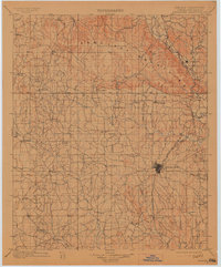
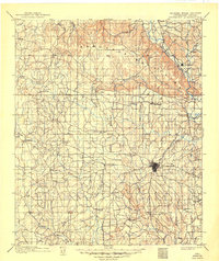
1901 Map of Ardmore
USGS Topo · Published 1913About this map
The Arbuckle Mountains dominate the northern landscape of this Chickasaw Nation survey, providing a backdrop for a territory defined by early industry and expanding rail lines. The Indian Meridian bisects the region, anchoring the township and range system that organized the land just prior to Oklahoma statehood. Ardmore serves as the central hub, situated along the Gulf Colorado and Santa Fe railroad which connects peripheral settlements like Dougherty and Overbrook. Several instances of Asphalt Mine labels reveal the early extraction of natural resources near Woodford and Dougherty. Beyond the rail corridors, the land is threaded with watercourses including the Washita River and Caddo Cr., supporting a network of small agricultural and crossroads communities such as Lonegrove, Healdton, and Graham.
Find a feature on this map
59 named features on this map. Tap any name to fly to it.
Don’t see what you’re looking for? This feature index may not catch every label — zoom into the map to look around manually.
Map Details
Editions of this 1901 Ardmore Map
6 editions found
Other maps of this area

1898 · Pauls Valley
USGS Topo · 1:125,000

1901 · Stonewall
USGS Topo · 1:125,000

1901 · Addington
USGS Topo · 1:125,000

1901 · Tishomingo
USGS Topo · 1:125,000

1901 · Ardmore
USGS Topo · 1:125,000

1901 · Denison
USGS Topo · 1:125,000

1902 · Gainesville
USGS Topo · 1:125,000

1902 · Pauls Valley
USGS Topo · 1:125,000

1902 · Rush Springs
USGS Topo · 1:125,000

1905 · Montague
USGS Topo · 1:125,000