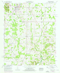
1958 Map of Ardmore
USGS Topo · Published 1976About this map
Ardmore straddles the state line between Alabama and Tennessee, serving as a primary rail and road hub at the intersection of the Louisville and Nashville railroad and the Pulaski Pike. The landscape is defined by the headwaters of Piney Creek and Little Limestone Creek, with the historical Old Chickasaw Boundary cutting diagonally across the southwestern section. The interior is dotted with rural community centers like Bethel and Oak Grove, alongside numerous family-named burial grounds including Hopwood and Gatlin cemeteries. A distinct pattern of small country schools and churches, such as Wooley Springs School and Mays Chapel, reveals the mid-century social structure of this borderland. Revision data from 1975 indicates suburban growth near Pine Dale and industrial additions like the Sewage disposal plant and a power Substation.
Find a feature on this map
62 named features on this map. Tap any name to fly to it.
Don’t see what you’re looking for? This feature index may not catch every label — zoom into the map to look around manually.
Map Details
Editions of this 1958 Ardmore Map
4 editions found
Other maps of this area

1888 · Huntsville
USGS Topo · 1:125,000

1892 · Huntsville
USGS Topo · 1:125,000

1935 · Athens
USGS Topo · 1:24,000

1936 · Jeff
USGS Topo · 1:24,000

1936 · Capshaw
USGS Topo · 1:24,000

1936 · Taft
USGS Topo · 1:24,000

1936 · Elkmont
USGS Topo · 1:24,000

1936 · Ardmore
USGS Topo · 1:24,000

1936 · Toney
USGS Topo · 1:24,000

1936 · Elkton
USGS Topo · 1:24,000