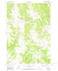
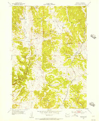
1955 Map of Argyle
USGS Topo · Published 1979About this map
Argyle and its surrounding ranchlands sit at a pivotal transition in the Black Hills, where the high timber of the Black Hills National Forest gives way to deep draws and canyons. This 1955 survey, updated with 1977 revisions, captures a specialized agricultural and industrial landscape defined by isolated family operations such as the Dean Ranch, Nicolls Ranch, and Waisnan Ranch. The local infrastructure is anchored by the Chicago Burlington and Quincy railroad, which follows the drainage south toward Argyle Canyon. Critical water sources like Dalton Spring and Upper Hand Spring suggest the importance of reliable water in this rugged South Dakota terrain. Notable landmarks for local historians include the Argyle Sch and the industrial activity at the Gravel Pit near Loring Siding.
Find a feature on this map
19 named features on this map. Tap any name to fly to it.
Don’t see what you’re looking for? This feature index may not catch every label — zoom into the map to look around manually.
Map Details
Editions of this 1955 Argyle Map
5 editions found
Other maps of this area

1896 · Harney Peak
USGS Topo · 1:125,000

1901 · Harney Peak
USGS Topo · 1:125,000

1902 · Edgemont
USGS Topo · 1:125,000

1950 · Edgemont NE
USGS Topo · 1:24,000

1950 · Minnekahta
USGS Topo · 1:24,000

1951 · Minnekahta NE
USGS Topo · 1:24,000

1954 · Fourmile
USGS Topo · 1:24,000

1954 · Jewel Cave SE
USGS Topo · 1:24,000

1955 · Jewel Cave
USGS Topo · 1:24,000
1955 · Argyle
USGS Topo · 1:24,000