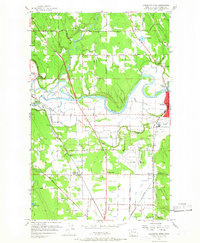
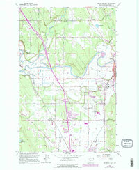
1956 Map of Arlington West
USGS Topo · Published 1966About this map
The StillAGUAmish River winds through the heart of this Snohomish County landscape, carving a wide alluvial plain that defines the local geography. At the center of the valley lies The Island, a distinct landform separated from the mainland by the South Slough and various drainage channels. This 1956 survey captures the area as it transitioned from a rural rail-dependent economy toward modern aviation and highway infrastructure. The presence of the Arlington Airport contrasts with the older settlement patterns established along the Northern Pacific railroad line, which connects communities like Lakewood (English Sta), Edgecomb, and Bryant.
Find a feature on this map
39 named features on this map. Tap any name to fly to it.
Don’t see what you’re looking for? This feature index may not catch every label — zoom into the map to look around manually.
Map Details
Editions of this 1956 Arlington West Map
6 editions found
Other maps of this area

1911 · Mount Vernon
USGS Topo · 1:125,000

1940 · Mt Vernon
USGS Topo · 1:62,500

1941 · Marysville
USGS Topo · 1:62,500

1943 · Marysville
USGS Topo · 1:62,500

1943 · Mt Vernon
USGS Topo · 1:62,500

1943 · Stanwood
USGS Topo · 1:62,500

1944 · Clear Lake
USGS Topo · 1:62,500

1956 · Tulalip
USGS Topo · 1:24,000

1956 · Arlington West
USGS Topo · 1:24,000

1956 · Arlington East
USGS Topo · 1:24,000