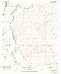
1955 Map of Artesia NE
USGS Topo · Published 1972About this map
The Lake Arthur settlement anchors the northwestern corner of this mid-century survey, situated along the Atchison Topeka and Santa Fe railroad line. This corridor follows the western bank of the Pecos River, which snakes through the center of the landscape, creating a distinct boundary between the river valley and the rising terrain of Buffalo Valley to the east. The river's influence on the local infrastructure is evident in the network of irrigation features, including a prominent Ditch and several reservoirs that supported agricultural efforts in this arid region.
Find a feature on this map
16 named features on this map. Tap any name to fly to it.
Don’t see what you’re looking for? This feature index may not catch every label — zoom into the map to look around manually.
Map Details
Editions of this 1955 Artesia NE Map
3 editions found
Other maps of this area

1951 · Ninemile Well
USGS Topo · 1:24,000

1951 · Diamond Mound
USGS Topo · 1:24,000

1951 · Hagerman
USGS Topo · 1:24,000

1952 · Hagerman SW
USGS Topo · 1:24,000

1953 · Espuela
USGS Topo · 1:24,000

1954 · Carlsbad
USGS Topo · 1:250,000

1955 · Artesia
USGS Topo · 1:24,000

1955 · Artesia NE
USGS Topo · 1:24,000

1955 · Spring Lake
USGS Topo · 1:24,000

1955 · Roswell
USGS Topo · 1:250,000