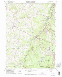
1961 Map of Ashville
USGS Topo · Published 1973About this map
Clearfield Creek serves as the central artery for this portion of the Allegheny Front, where industrial activity and small-town settlements are closely tied to the corridor of the Penn Central railroad. The landscape is heavily marked by extractive industry, featuring numerous mines and extensive strip mines that follow the coal seams of the Gallitzin and Dean areas. Settlements like Ashville and Coupon are established along the ridge lines and valley floors, supported by a network of religious and civic sites including St Monica Cath Ch and the St Josephs Ch.
Find a feature on this map
47 named features on this map. Tap any name to fly to it.
Don’t see what you’re looking for? This feature index may not catch every label — zoom into the map to look around manually.
Map Details
Editions of this 1961 Ashville Map
3 editions found
Other maps of this area

1902 · Ebensburg
USGS Topo · 1:62,500

1902 · Patton
USGS Topo · 1:62,500

1902 · Hollidaysburg
USGS Topo · 1:62,500

1903 · Hollidaysburg
USGS Topo · 1:62,500

1904 · Patton
USGS Topo · 1:62,500

1904 · Ebensburg
USGS Topo · 1:62,500

1920 · Altoona
USGS Topo · 1:62,500

1922 · Altoona
USGS Topo · 1:62,500

1943 · Punxsutawney
USGS Topo · 1:125,000

1953 · Pittsburgh
USGS Topo · 1:250,000