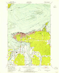
1949 Map of Astoria
USGS Topo · Published 1955About this map
Astoria serves as the focal point of this coastal survey, situated where the Columbia River meets its southern tributaries at the mouth of the estuary. The postwar landscape is defined by its maritime and military presence, notably at the Tongue Point Naval Base and the adjacent Tongue Point Village. The city’s steep topography is marked by Coxcomb Hill, home to the Astor Column, and the dense street grid that transitions into the newer residential developments of Navy Heights. Along the waterfront, the Spokane Portland and Seattle railroad follows the shoreline toward the expansive tidal flats of Cathlamet Bay. To the south, the map details the rural character of Miles Crossing and the confluence of the Youngs River and Walluski River, providing a look at the region’s hydraulic network before late-century changes.
Find a feature on this map
53 named features on this map. Tap any name to fly to it.
Don’t see what you’re looking for? This feature index may not catch every label — zoom into the map to look around manually.
Map Details
Editions of this 1949 Astoria Map
4 editions found
Other maps of this area

1919 · Astoria
USGS Topo · 1:62,500

1938 · Fort Columbia
USGS Topo · 1:62,500

1939 · Astoria
USGS Topo · 1:62,500

1940 · Svensen
USGS Topo · 1:62,500

1940 · Brookfield
USGS Topo · 1:62,500

1943 · Fort Columbia
USGS Topo · 1:62,500

1949 · Astoria
USGS Topo · 1:24,000

1949 · Chinook
USGS Topo · 1:24,000

1949 · Knappton
USGS Topo · 1:24,000

1949 · Cathlamet Bay
USGS Topo · 1:24,000