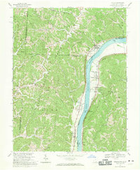
1968 Map of Athalia
USGS Topo · Published 1970About this map
The Ohio River valley serves as the primary corridor for settlement and industry in this 1968 study, where the Baltimore and Ohio railroad tracks trace the West Virginia shoreline through Green Bottom and Lesage. Across the water in Ohio, the villages of Athalia and Crown City anchor the riverbank, while the interior is defined by the Wayne National Forest Boundary and a network of winding hollows.
Find a feature on this map
63 named features on this map. Tap any name to fly to it.
Don’t see what you’re looking for? This feature index may not catch every label — zoom into the map to look around manually.
Map Details
Editions of this 1968 Athalia Map
4 editions found
Other maps of this area

1892 · Huntington
USGS Topo · 1:125,000

1898 · Huntington
USGS Topo · 1:125,000

1901 · Guyandot
USGS Topo · 1:62,500

1902 · Guyandot
USGS Topo · 1:62,500

1902 · Milton
USGS Topo · 1:62,500

1906 · Athalia
USGS Topo · 1:62,500

1906 · Glenwood
USGS Topo · 1:62,500

1908 · Athalia
USGS Topo · 1:62,500

1908 · Glenwood
USGS Topo · 1:62,500

1931 · Milton
USGS Topo · 1:62,500