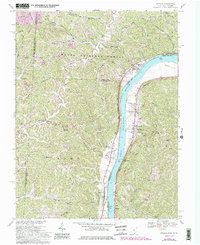
1968 Map of Athalia
USGS Topo · Published 1985About this map
Ohio River frontage defines this borderland between Lawrence and Gallia Counties, where the Baltimore and Ohio line follows the West Virginia bank opposite the settlements of Athalia and Crown City. The landscape transitions from the broad river bottom to the deeply incised ridges of the Wayne National Forest, marked by numerous country churches such as Center Point Ch and Good Hope Ch. Evidence of the region’s extractive economy appears on the western ridges near Polkadotte, where several Strip Mines are mapped among the tributaries of Indian Guyan Creek.
Find a feature on this map
58 named features on this map. Tap any name to fly to it.
Don’t see what you’re looking for? This feature index may not catch every label — zoom into the map to look around manually.
Map Details
Editions of this 1968 Athalia Map
4 editions found
Other maps of this area

1892 · Huntington
USGS Topo · 1:125,000

1898 · Huntington
USGS Topo · 1:125,000

1901 · Guyandot
USGS Topo · 1:62,500

1902 · Guyandot
USGS Topo · 1:62,500

1902 · Milton
USGS Topo · 1:62,500

1906 · Athalia
USGS Topo · 1:62,500

1906 · Glenwood
USGS Topo · 1:62,500

1908 · Athalia
USGS Topo · 1:62,500

1908 · Glenwood
USGS Topo · 1:62,500

1931 · Milton
USGS Topo · 1:62,500