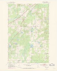
1954 Map of Atkinson
USGS Topo · Published 1971About this map
Atkinson and Duesler anchor this Carlton County landscape, where the Burlington Northern and Soo Line railroads carve paths through a dense network of water and wetlands. The terrain is defined by its glacial heritage, featuring numerous lakes including Sandy Lake, Blackhoof Lake, and Flodin Lake, while the Moose River and Blackhoof River drain the northern reaches. This 1954 survey, with 1969 revisions, documents a rural community centered on its local institutions, from the Blackhoof Valley Sch and Central Sch to numerous neighborhood houses of worship like Pentecost Ch and Elim Ch. To the south, the Nemadji State Forest boundary signals the transition into protected timberlands. The map reveals the intricate infrastructure of the era, including a major pipeline and various gravel pits that underscore the area's mid-century industrial and transport utility.
Find a feature on this map
36 named features on this map. Tap any name to fly to it.
Don’t see what you’re looking for? This feature index may not catch every label — zoom into the map to look around manually.
Map Details
Editions of this 1954 Atkinson Map
3 editions found
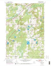
Other maps of this area

1949 · Holyoke
USGS Topo · 1:48,000

1953 · Duluth
USGS Topo · 1:250,000

1954 · Cloquet
USGS Topo · 1:24,000

1954 · Wrenshall
USGS Topo · 1:24,000

1954 · Atkinson
USGS Topo · 1:24,000

1954 · Iverson
USGS Topo · 1:24,000

1954 · Sawyer
USGS Topo · 1:24,000

1956 · Barnum
USGS Topo · 1:62,500

1958 · Duluth
USGS Topo · 1:250,000

1962 · Holyoke
USGS Topo · 1:62,500