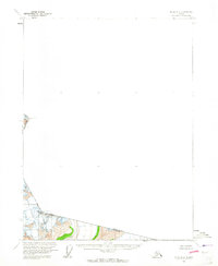
1960 Map of Atlin B-8
USGS Topo · Published 1965About this map
The international border between British Columbia and Alaska dominates this high-altitude survey, illustrating the complex geography of the northern Tongass National Forest. Mapped using aerial photography from 1948, the terrain is defined by an Indefinite Boundary where glaciers and steep relief challenged the precision of early terrestrial surveys. Prominent high points along the Canada-United States line include Snow Top and Boundary Peak 106, which serve as critical markers for the International Boundary Commission. The lack of roads or established settlements on this sheet highlights the wilderness state of the region during the mid-20th century, focused entirely on the cartography of the frontier peaks such as Boundary Peak 108.
Find a feature on this map
10 named features on this map. Tap any name to fly to it.
Don’t see what you’re looking for? This feature index may not catch every label — zoom into the map to look around manually.
Map Details
Editions of this 1960 Atlin B-8 Map
2 editions found
Other maps of this area

1948 · Skagway A-1
USGS Topo · 1:63,360

1948 · Skagway C-1
USGS Topo · 1:63,360

1949 · Atlin
USGS Topo · 1:250,000

1949 · Skagway B-1
USGS Topo · 1:63,360

1951 · Skagway A-1
USGS Topo · 1:63,360

1951 · Skagway C-1
USGS Topo · 1:63,360

1951 · Atlin
USGS Topo · 1:250,000

1951 · Skagway B-1
USGS Topo · 1:63,360

1952 · Skagway
USGS Topo · 1:250,000

1960 · Atlin A-8
USGS Topo · 1:63,360