
1960 Map of Atlin
USGS Topo · Published 1966About this map
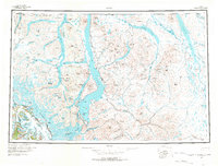
The White Pass and Yukon RR traverses the western edge of this territory, tracing the historic corridor through White Pass toward the settlement of Bennett. This map documents a complex borderland where the Alaska-British Columbia and United States-Canada boundaries intersect amidst an expansive network of glacially carved lakes and alpine peaks. The settlement of Atlin serves as a central hub on the eastern shore of Atlin Lake, while the western waters are dominated by the massive reaches of Tagish Lake and its Taku Arm. Evidence of the region's industrial history is visible at the Engineer (Site) and Teepee (Site), marking the locations of earlier mining operations. The southern portion of the sheet is defined by the colossal Llewellyn Glacier, highlighting the ice-bound nature of the Coast Mountains during the mid-20th century.
Find a feature on this map
189 named features on this map. Tap any name to fly to it.
Don’t see what you’re looking for? This feature index may not catch every label — zoom into the map to look around manually.
Map Details
Editions of this 1960 Atlin Map
2 editions found
Other maps of this area

1948 · Juneau D-3
USGS Topo · 1:63,360

1948 · Skagway A-1
USGS Topo · 1:63,360

1948 · Skagway C-1
USGS Topo · 1:63,360

1949 · Atlin
USGS Topo · 1:250,000

1949 · Skagway B-1
USGS Topo · 1:63,360

1949 · Juneau D-4
USGS Topo · 1:63,360

1949 · Juneau D-3
USGS Topo · 1:63,360

1951 · Juneau
USGS Topo · 1:250,000

1951 · Skagway A-1
USGS Topo · 1:63,360

1951 · Skagway C-1
USGS Topo · 1:63,360