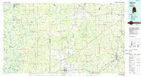
1986 Map of Atmore
USGS Topo · Published 1986About this map
The Alabama River and Tombigbee River snake through a landscape of dense river bottoms and upland pine forests in this mid-1980s look at Escambia, Monroe, and Clarke Counties. The map captures a transition in Southern land management, showing the Stimpson State Game Sanctuary and the Little River State Forest alongside industrial and correctional infrastructure like the G K Fountain Correctional Center.
Find a feature on this map
344 named features on this map. Tap any name to fly to it.
Don’t see what you’re looking for? This feature index may not catch every label — zoom into the map to look around manually.
Map Details
Editions of this 1986 Atmore Map
2 editions found
Other maps of this area

1941 · Bay Minette
USGS Topo · 1:62,500

1941 · Creola
USGS Topo · 1:62,500

1941 · Century
USGS Topo · 1:62,500

1942 · Perdido
USGS Topo · 1:62,500

1942 · Dyas
USGS Topo · 1:62,500

1943 · Creola
USGS Topo · 1:62,500

1943 · Century
USGS Topo · 1:62,500

1943 · Bay Minette
USGS Topo · 1:62,500

1943 · Jay
USGS Topo · 1:62,500

1943 · Choctaw Bluff
USGS Topo · 1:62,500