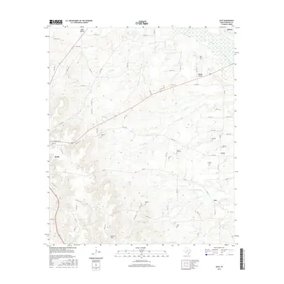
2016 Map of Atoy
USGS Topo · Published 2016About this map
Rusk and the rural communities of Atoy and Circle anchor this portion of Cherokee County, where the landscape is defined by the headwaters of numerous creeks feeding the regional river systems. The terrain transitions from the elevations of Bradford Mtn in the south toward the marshy lowlands of Mud Cr and the Rutherford Slough in the northeast. This 2016 survey documents a dense network of country roads connecting established family cemeteries, including Walker Cem, Meredith Cem, and Cornelius Cem, which serve as vital markers of the area's genealogical history. The drainage pattern is particularly intricate, with N Falcon Cr, S Falcon Cr, and Cooke Cr carving through the timbered hills. The presence of Myrtle Spring and Macedonia Cem near the center of the sheet highlights the long-standing importance of water sources and community hubs in this East Texas interior.
Find a feature on this map
79 named features on this map. Tap any name to fly to it.
Don’t see what you’re looking for? This feature index may not catch every label — zoom into the map to look around manually.
Map Details
Editions of this 2016 Atoy Map
This is the sole edition of this map. No revisions or reprints were ever made.
Other maps of this area

1943 · Cushing
USGS Topo · 1:62,500

1943 · Rusk
USGS Topo · 1:62,500

1945 · Cushing
USGS Topo · 1:62,500

1945 · Rusk
USGS Topo · 1:62,500

1946 · Alto
USGS Topo · 1:62,500

1952 · Douglass
USGS Topo · 1:62,500

1953 · Palestine
USGS Topo · 1:250,000

1957 · Palestine
USGS Topo · 1:250,000
1973 · New Summerfield
USGS Topo · 1:24,000
1973 · Jacksonville East
USGS Topo · 1:24,000