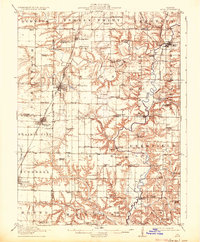
1915 Map of Avon
USGS Topo · Published 1933About this map
The Spoon River meanders through the heart of the Illinois prairie in this early twentieth-century survey, creating a diverse landscape where the rugged bluffs of the river valley meet the flat agricultural tablelands of Fulton County. The region's early rural development is remarkably dense, characterized by an extensive network of one-room schools like Gooseneck School and Hazel Ridge School, which served the farming communities of Indian Point and Deerfield. The settlement pattern follows the Chicago and Burlington railroad, which links established towns such as Avon and Bushnell. Along the river, smaller outposts like Babylon and London Mills mark historic crossing points, with specialized landmarks including Templars Hall and the Indian Ford Bridge illustrating the social and physical infrastructure that connected these isolated townships before the advent of modern highways.
Find a feature on this map
85 named features on this map. Tap any name to fly to it.
Don’t see what you’re looking for? This feature index may not catch every label — zoom into the map to look around manually.
Map Details
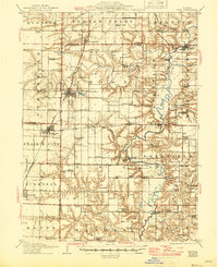
Editions of this 1915 Avon Map
3 editions found
Other maps of this area

1912 · Canton
USGS Topo · 1:62,500

1912 · Macomb
USGS Topo · 1:62,500

1914 · Macomb
USGS Topo · 1:62,500

1915 · Avon
USGS Topo · 1:62,500

1916 · Good Hope
USGS Topo · 1:62,500

1918 · Vermont
USGS Topo · 1:62,500

1918 · Good Hope
USGS Topo · 1:62,500

1921 · Vermont
USGS Topo · 1:62,500

1921 · Monmouth
USGS Topo · 1:62,500

1923 · Monmouth
USGS Topo · 1:62,500