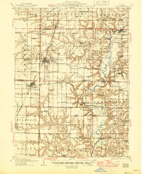
1915 Map of Avon
USGS Topo · Published 1945About this map
Avon and Bushnell anchor this detailed study of the west-central Illinois prairie as it appeared during the transition to more modern infrastructure. The landscape is defined by a dense network of early 20th-century rural schools, including Oldtown School, Olive School, and Gooseneck School, illustrating the localized nature of education before consolidation. The Spoon River meanders through the eastern portion, punctuated by historic crossings such as Indian Ford Bridge and the Buckeye Bridge. Transportation is heavily influenced by the intersecting lines of the Chicago Burlington and Quincy and the Toledo Peoria and Western railroads, which facilitated the growth of settlements like Prairie City and St Augustine. Notable community landmarks such as Templars Hall and the settlement at Babylon provide specific points of interest for local history and genealogical research.
Find a feature on this map
87 named features on this map. Tap any name to fly to it.
Don’t see what you’re looking for? This feature index may not catch every label — zoom into the map to look around manually.
Map Details
Editions of this 1915 Avon Map
3 editions found
Other maps of this area

1912 · Canton
USGS Topo · 1:62,500

1912 · Macomb
USGS Topo · 1:62,500

1914 · Macomb
USGS Topo · 1:62,500

1915 · Avon
USGS Topo · 1:62,500

1916 · Good Hope
USGS Topo · 1:62,500

1918 · Vermont
USGS Topo · 1:62,500

1918 · Good Hope
USGS Topo · 1:62,500

1921 · Vermont
USGS Topo · 1:62,500

1921 · Monmouth
USGS Topo · 1:62,500

1923 · Monmouth
USGS Topo · 1:62,500