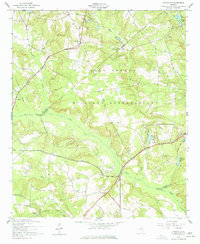
1957 Map of Avondale
USGS Topo · Published 1978About this map
Fort Gordon Military Reservation dominates the central landscape of this 1957 survey, illustrating a massive transition from rural land use to military infrastructure across the borders of Richmond, McDuffie, and Columbia counties. The map preserves the specific locations of several rural congregational sites and family burial grounds, such as Silver Run Ch, Woodland Ch, and Arrington Cem, many of which sit within or on the margins of the federal installation. The drainage of Brier Creek and its many tributaries, including Hard Fortune Creek and Boggy Gut Creek, create a complex network of wetlands and ponds. Notable water features like George Claussen Pond and the Nortons Millrace point to earlier agricultural and light industrial uses of these riparian corridors before mid-century changes. The presence of the County Line Monument underscores the precise surveying required where four distinct counties converge.
Find a feature on this map
39 named features on this map. Tap any name to fly to it.
Don’t see what you’re looking for? This feature index may not catch every label — zoom into the map to look around manually.
Map Details
Editions of this 1957 Avondale Map
3 editions found
Other maps of this area

1919 · Gough
USGS Topo · 1:62,500

1920 · Stapleton
USGS Topo · 1:62,500

1922 · Harlem
USGS Topo · 1:62,500

1922 · Hephzibah
USGS Topo · 1:62,500

1948 · Hephzibah
USGS Topo · 1:62,500

1948 · Harlem
USGS Topo · 1:62,500

1948 · Stapleton
USGS Topo · 1:62,500

1948 · Gough
USGS Topo · 1:62,500

1948 · Blythe
USGS Topo · 1:24,000

1948 · Harlem
USGS Topo · 1:24,000