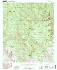
1986 Map of Aztec Peak
USGS Topo · Published 1986About this map
Aztec Peak dominates the skyline of the Sierra Ancha Wilderness within the Tonto National Forest in this mid-1980s topographical study. The terrain is defined by dramatic elevation changes, from the deep cuts of Devils Chasm and Parker Canyon to the high ridges of Baker Mountain and Armer Mountain. Evidence of early extraction persists through numerous Prospects and Tunnels near Asbestos Point, while the natural hydrology of the region is mapped through a series of essential water sources including Armor Corral Spring, Tewksbury Spring, and Mud Spring. The survey detail captures the complex drainage of the Workman Creek and Reynolds Creek basins, illustrating the remote and steep character of central Arizona before the widespread digitization of land records. Notable landmarks such as Poney Creek Divide and Workman Creek Falls provide clear geographic reference points for the area.
Find a feature on this map
48 named features on this map. Tap any name to fly to it.
Don’t see what you’re looking for? This feature index may not catch every label — zoom into the map to look around manually.
Map Details
Editions of this 1986 Aztec Peak Map
2 editions found
Other maps of this area

1907 · Roosevelt
USGS Topo · 1:125,000

1909 · Four Peaks
USGS Topo · 1:125,000

1912 · Roosevelt
USGS Topo · 1:125,000

1922 · Chrysotile
USGS Topo · 1:125,000

1949 · McFadden Peak
USGS Topo · 1:62,500

1949 · Rockinstraw Mtn
USGS Topo · 1:62,500

1950 · Rockinstraw Mtn
USGS Topo · 1:62,500

1950 · McFadden Peak
USGS Topo · 1:62,500

1954 · Mesa
USGS Topo · 1:250,000

1957 · Mesa
USGS Topo · 1:250,000