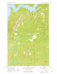
1952 Map of Babbitt NE
USGS Topo · Published 1976About this map
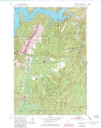
Birch Lake and its intricate northern bays define this landscape at the edge of the Minnesota State Forest and Superior National Forest. The map captures a transition toward industrial extraction, marked by the extensive Reserve Mining Company Railroad and several sprawling Mine Dumps that contrast with the primitive terrain. Along the southern shore, Norway Point and Birch Point reach into the reservoir waters, where soundings reveal the original lake depths. Inland, the footprint of earlier activity remains visible at the Tomahawk Camp (Abandoned) and an Old Landing Field. The Dunka River and Stony River thread through the lowlands, illustrating the region's complex water network before late-twentieth-century mining further altered the topography of St. Louis and Lake Counties.
Find a feature on this map
21 named features on this map. Tap any name to fly to it.
Don’t see what you’re looking for? This feature index may not catch every label — zoom into the map to look around manually.
Map Details
Editions of this 1952 Babbitt NE Map
6 editions found
Other maps of this area

1933 · Ely
USGS Topo · 1:62,500

1939 · Ely
USGS Topo · 1:62,500

1951 · Babbitt SW
USGS Topo · 1:24,000

1951 · Babbitt
USGS Topo · 1:24,000

1952 · Babbitt SE
USGS Topo · 1:24,000

1952 · Babbitt NE
USGS Topo · 1:24,000

1954 · Greenwood Lake
USGS Topo · 1:62,500

1954 · Two Harbors
USGS Topo · 1:250,000

1957 · Two Harbors
USGS Topo · 1:250,000

1957 · Gabbro Lake
USGS Topo · 1:62,500
Featured Places
- Babbitt, MN
- Stony River Township, MN
- Bassett Township, MN
- Birch Lake (Unorganized Territory), MN
- Lake No. 2, MN