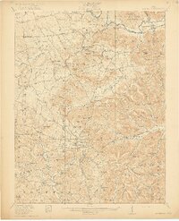
1917 Map of Bainbridge
USGS Topo · Published 1917About this map
Ancient earthworks and a densely settled rural landscape define this southern Ohio region during the early twentieth century. The map prominently features the Serpent Mound in the south, while Fort Hill and an Indian Mound near Bainbridge highlight the deep cultural history of the Paint Creek valley. The terrain is marked by significant elevations like Irons Mountain and Starr Mountain, with drainage provided by the Rocky Fork and Sunfish Creek. Small agricultural communities and mill sites are scattered throughout, including Barretts Mills and Sinking Spring. A network of early transportation routes, such as the Cincinnati Road and Waverly Road, connects numerous one-room schoolhouses like Cedar Chapel School and Snake Corners School. This survey captures the transition from horse-and-buggy travel to the early automobile era, evidenced by named junctions such as Spellman Crossing.
Find a feature on this map
139 named features on this map. Tap any name to fly to it.
Don’t see what you’re looking for? This feature index may not catch every label — zoom into the map to look around manually.
Map Details
Editions of this 1917 Bainbridge Map
4 editions found
Other maps of this area

1912 · Roxabell
USGS Topo · 1:62,500

1914 · Roxabell
USGS Topo · 1:62,500

1915 · Bainbridge
USGS Topo · 1:48,000

1915 · Otway
USGS Topo · 1:62,500

1915 · Piketon
USGS Topo · 1:62,500

1916 · Peebles
USGS Topo · 1:62,500

1917 · Bainbridge
USGS Topo · 1:62,500

1917 · Piketon
USGS Topo · 1:62,500

1917 · Greenfield
USGS Topo · 1:62,500

1917 · Hillsboro
USGS Topo · 1:62,500