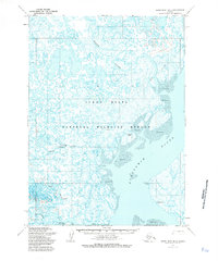
1954 Map of Baird Inlet B-2
USGS Topo · Published 1985About this map
The intricate waterways of the Yukon Delta National Wildlife Refuge define this coastal landscape as it was mapped in the mid-1950s. The settlement at Tuntutuliak sits at the confluence of the Kinak River and the sprawling Kuskokwim River, serving as a focal point for regional activity with its Seaplane Anchorage and Landing Strip. To the north and west, the terrain is dominated by a complex web of channels, including the Kialik River, Jewn River, and Tagayarak River, weaving through tidal flats and wetlands labeled as mud and sand. This survey captures the remote infrastructure of the era, such as a Winter Trail cutting across the delta and the identified Kinak (Site) and Akulurak. The map highlights the reliance on water and air transport in a region where tidal ranges at Helmick Point can reach four feet, shaping the seasonal movement and subsistence patterns of the Bethel area.
Find a feature on this map
15 named features on this map. Tap any name to fly to it.
Don’t see what you’re looking for? This feature index may not catch every label — zoom into the map to look around manually.
Map Details
Editions of this 1954 Baird Inlet B-2 Map
2 editions found
Other maps of this area

1951 · Baird Inlet
USGS Topo · 1:250,000

1954 · Baird Inlet A-3
USGS Topo · 1:63,360

1954 · Baird Inlet
USGS Topo · 1:250,000

1954 · Baird Inlet B-1
USGS Topo · 1:63,360
1954 · Baird Inlet A-1
USGS Topo · 1:63,360
1954 · Baird Inlet C-1
USGS Topo · 1:63,360
1954 · Baird Inlet C-2
USGS Topo · 1:63,360
1954 · Baird Inlet A-2
USGS Topo · 1:63,360
1954 · Baird Inlet C-3
USGS Topo · 1:63,360

1954 · Baird Inlet B-3
USGS Topo · 1:63,360