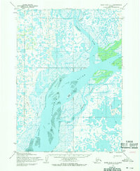
1954 Map of Baird Inlet C-1
USGS Topo · Published 1968About this map
The Kuskokwim River dominates this mid-century landscape, carving a wide path through the complex wetlands of the Yukon-Kuskokwim Delta. Near the junction of the Johnson River and the Kongeruk River, the map reveals a network of seasonal transit and small outposts. This era of the territory is marked by small named points of occupation such as Nance, Whim, Johnson, and Loma, which sit amongst the vast Tidal Flats and marshy lowlands. Local movement relied heavily on the Winter Trail systems that crisscross the tundra, connecting these isolated cabins and river points. Topographic details like Fowler Island and Bear Point serve as essential landmarks for navigation through the Lomavik Slough, where the shifting water levels and intricate drainage patterns defined the subsistence lifestyle of the region.
Find a feature on this map
22 named features on this map. Tap any name to fly to it.
Don’t see what you’re looking for? This feature index may not catch every label — zoom into the map to look around manually.
Map Details
Editions of this 1954 Baird Inlet C-1 Map
3 editions found
Other maps of this area

1950 · Bethel
USGS Topo · 1:250,000

1951 · Baird Inlet
USGS Topo · 1:250,000

1954 · Bethel D-8
USGS Topo · 1:63,360

1954 · Bethel B-8
USGS Topo · 1:63,360

1954 · Bethel C-8
USGS Topo · 1:63,360

1954 · Baird Inlet
USGS Topo · 1:250,000

1954 · Baird Inlet B-1
USGS Topo · 1:63,360
1954 · Baird Inlet D-1
USGS Topo · 1:63,360
1954 · Baird Inlet C-2
USGS Topo · 1:63,360
1954 · Baird Inlet D-2
USGS Topo · 1:63,360