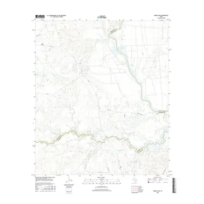
2016 Map of Baker Lake
USGS Topo · Published 2016About this map
Larrison Cr and the winding course of the Trinity River define the topography where Walker, Madison, and Houston Counties meet. This 2016 survey shows a landscape dominated by timber and water management, featuring several significant impoundments including Eastham Reservoir and Ferguson Reservoir Number 1. The western portion of the map is marked by the small settlement of Bald Prairie and a network of county roads like Co RD 134 and FM 1428 that navigate the low-lying wetlands. Historically minded researchers can find Falba Cem situated near Cedar Cr in the southern section. The map documents the intricate hydrology of the region, from the wide expanse of Lake Livingston in the northeast to the smaller oxbow-style lakes like Marks Lake and Baker Lake. This survey illustrates the modern rural infrastructure and water resources that have shaped this pocket of East Texas.
Find a feature on this map
38 named features on this map. Tap any name to fly to it.
Don’t see what you’re looking for? This feature index may not catch every label — zoom into the map to look around manually.
Map Details
Editions of this 2016 Baker Lake Map
This is the sole edition of this map. No revisions or reprints were ever made.
Other maps of this area

1953 · Palestine
USGS Topo · 1:250,000

1954 · Beaumont
USGS Topo · 1:250,000

1957 · Beaumont
USGS Topo · 1:250,000

1957 · Palestine
USGS Topo · 1:250,000

1962 · Pine Prairie
USGS Topo · 1:24,000

1962 · Connor
USGS Topo · 1:24,000

1962 · Wyser Bottom
USGS Topo · 1:24,000

1962 · Baker Lake
USGS Topo · 1:24,000

1963 · Steep Branch
USGS Topo · 1:24,000

1963 · Crabbs Prairie
USGS Topo · 1:24,000