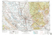
1962 Map of Bakersfield
USGS Topo · Published 1973About this map
Bakersfield serves as the focal point for this expansive look at the southern San Joaquin Valley and the surrounding mountain ranges. The landscape is a study in contrasts, from the intensive agricultural grid and numerous Oil Field sites on the Antelope Plain to the steep rises of the Sierra Nevada and Tehachapi Mountains. The map traces the critical water infrastructure of the era, including the California Aqueduct and Friant-Kern Canal, which supported the region's growth. To the west, the Naval Petroleum Reserve No 1 and Naval Petroleum Reserve No 2 highlight the strategic importance of the area's energy resources. The eastern half is dominated by the wilderness of the Sequoia National Forest, featuring landmarks like Isabella Lake and the high peaks of the Piute Mountains. This 1971 revision captures the valley's mid-century transition as modern highways like U.S. 99 replaced older transport corridors.
Find a feature on this map
107 named features on this map. Tap any name to fly to it.
Don’t see what you’re looking for? This feature index may not catch every label — zoom into the map to look around manually.
Map Details
Editions of this 1962 Bakersfield Map
4 editions found
Other maps of this area

1902 · Santa Ynez
USGS Topo · 1:125,000

1903 · Mt. Pinos
USGS Topo · 1:125,000

1903 · Tejon
USGS Topo · 1:125,000

1904 · Kaweah
USGS Topo · 1:125,000

1905 · Santa Ynez
USGS Topo · 1:125,000

1905 · Lompoc
USGS Topo · 1:125,000

1905 · Olancha
USGS Topo · 1:125,000

1905 · Fairview
USGS Topo · 1:24,000

1906 · Bakersfield
USGS Topo · 1:62,500

1906 · Kernville
USGS Topo · 1:125,000