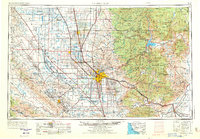
1962 Map of Bakersfield
USGS Topo · Published 1973About this map
Bakersfield stands as the central hub of a landscape defined by industrial extraction and massive water engineering projects in the early 1960s. The western valley floor is dominated by extensive Oil Field operations and the sprawling boundaries of Naval Petroleum Reserve No. 1 and Naval Petroleum Reserve No. 2. This energy corridor is paralleled by an intricate network of irrigation, featuring the California Aqueduct, the Friant-Kern Canal, and numerous smaller channels like the Beardsley and Lerdo Canal.
Find a feature on this map
163 named features on this map. Tap any name to fly to it.
Don’t see what you’re looking for? This feature index may not catch every label — zoom into the map to look around manually.
Map Details
Editions of this 1962 Bakersfield Map
4 editions found
Other maps of this area

1902 · Santa Ynez
USGS Topo · 1:125,000

1903 · Mt. Pinos
USGS Topo · 1:125,000

1903 · Tejon
USGS Topo · 1:125,000

1904 · Kaweah
USGS Topo · 1:125,000

1905 · Santa Ynez
USGS Topo · 1:125,000

1905 · Lompoc
USGS Topo · 1:125,000

1905 · Olancha
USGS Topo · 1:125,000

1905 · Fairview
USGS Topo · 1:24,000

1906 · Bakersfield
USGS Topo · 1:62,500

1906 · Kernville
USGS Topo · 1:125,000