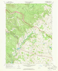
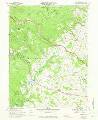
1967 Map of Bakersville
USGS Topo · Published 1971About this map
Laurel Hill divides the landscape of this 1967 survey, where the Pennsylvania Turnpike cuts a bold path through the dense Forbes State Forest. The map captures a moment of established recreation and rural life in Somerset County, featuring Kooser State Park and the Plateau De Mount Ski Area near the Westmoreland border. This era shows a transition in land use, as an Old Railroad Grade winds through the hills, no longer serving its original purpose, while the turnpike facilitates modern travel through the ridge.
Find a feature on this map
64 named features on this map. Tap any name to fly to it.
Don’t see what you’re looking for? This feature index may not catch every label — zoom into the map to look around manually.
Map Details
Editions of this 1967 Bakersville Map
5 editions found
Other maps of this area

1913 · Somerset
USGS Topo · 1:62,500

1915 · Somerset
USGS Topo · 1:62,500

1921 · Meyersdale
USGS Topo · 1:62,500

1922 · Confluence
USGS Topo · 1:62,500

1922 · Donegal
USGS Topo · 1:62,500

1931 · Confluence
USGS Topo · 1:62,500

1933 · Confluence
USGS Topo · 1:62,500

1935 · Donegal
USGS Topo · 1:62,500

1939 · Meyersdale
USGS Topo · 1:62,500

1944 · Somerset
USGS Topo · 1:62,500
Featured Places
- Somerset Township, PA
- Milford Township, PA
- Lincoln Township, PA
- Middlecreek Township, PA
- Allenvale, Jefferson Township