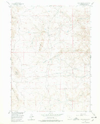
1955 Map of Baldy Mountain
USGS Topo · Published 1978About this map
The eastern foothills of the Laramie Mountains define this landscape, where high-altitude ranching and complex drainage patterns intersect. Surveyed for the development of the Missouri River Basin, the topography is dominated by the prominent summit of Baldy Mountain and a distinctive formation known as The Buttes. The area's hydrology is characterized by numerous small tributaries and seasonal flows, including the headwaters of Middle Chugwater Creek and South Chugwater Creek. Human presence is sparse, anchored by the Greaser Ranch situated along Strong Creek. The map details a network of unimproved roads and trails that traverse the terrain, following the natural breaks of the land between Middle Sybille Creek and Shanton Creek, reflecting the isolation and functional layout of mid-century Wyoming cattle country.
Find a feature on this map
12 named features on this map. Tap any name to fly to it.
Don’t see what you’re looking for? This feature index may not catch every label — zoom into the map to look around manually.
Map Details
Editions of this 1955 Baldy Mountain Map
3 editions found

Other maps of this area

1895 · Laramie
USGS Topo · 1:125,000

1902 · Laramie
USGS Topo · 1:125,000

1905 · Sherman
USGS Topo · 1:125,000

1905 · Laramie
USGS Topo · 1:125,000

1906 · Laramie
USGS Topo · 1:125,000

1908 · Laramie
USGS Topo · 1:125,000

1948 · Ragged Top Mountain
USGS Topo · 1:62,500

1950 · Ragged Top Mountain
USGS Topo · 1:62,500

1954 · Cheyenne
USGS Topo · 1:250,000

1955 · Bosler SE
USGS Topo · 1:24,000