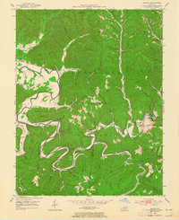
1953 Map of Bangor
USGS Topo · Published 1965About this map
The Licking River winds through the heart of this landscape, carving deep oxbows as it forms the boundary between Rowan, Bath, Menifee, and Morgan counties. The settlement pattern in the early 1950s follows the narrow river valleys and their numerous tributaries, such as Claylick Creek and Yocum Creek. Small rural communities like Bangor and Paragon anchor the region, while the Cumberland National Forest blankets much of the high ground. Educational life is remarkably decentralized, with several local institutions including Mt Hope Sch, Donahue Sch, and Licking River Sch serving these scattered valley homes. Notable landmarks include the Poppin Rock Tunnel and the prominent Lockegee Rock, illustrating a rugged topography where transport was often limited to river-parallel roads and occasional river-crossing points like the Ford near Bangor.
Find a feature on this map
76 named features on this map. Tap any name to fly to it.
Don’t see what you’re looking for? This feature index may not catch every label — zoom into the map to look around manually.
Map Details
Editions of this 1953 Bangor Map
2 editions found

Other maps of this area

1889 · Salyersville
USGS Topo · 1:125,000

1891 · Salyersville
USGS Topo · 1:125,000

1892 · Beattyville
USGS Topo · 1:125,000

1899 · Salyersville
USGS Topo · 1:125,000

1929 · Morehead
USGS Topo · 1:48,000

1929 · Salt Lick
USGS Topo · 1:62,500

1934 · Salt Lick
USGS Topo · 1:62,500

1935 · Morehead
USGS Topo · 1:62,500

1951 · Ezel
USGS Topo · 1:24,000
1951 · West Liberty
USGS Topo · 1:24,000