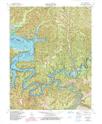
1979 Map of Bangor
USGS Topo · Published 1993About this map
The Licking River valley, as it appeared following the creation of Cave Run Lake, dominates this topographic study of the Daniel Boone National Forest boundary. The map captures a landscape in transition, where rising waters at Elevation 730 defined new shorelines around former river bottoms. Small settlements like Bangor and Paragon remain perched near the intricate drainage networks of the North Fork Licking River and Yocum Cr.
Find a feature on this map
50 named features on this map. Tap any name to fly to it.
Don’t see what you’re looking for? This feature index may not catch every label — zoom into the map to look around manually.
Map Details
Editions of this 1979 Bangor Map
2 editions found
Other maps of this area

1889 · Salyersville
USGS Topo · 1:125,000

1891 · Salyersville
USGS Topo · 1:125,000

1892 · Beattyville
USGS Topo · 1:125,000

1899 · Salyersville
USGS Topo · 1:125,000

1929 · Morehead
USGS Topo · 1:48,000

1929 · Salt Lick
USGS Topo · 1:62,500

1934 · Salt Lick
USGS Topo · 1:62,500

1935 · Morehead
USGS Topo · 1:62,500

1951 · Ezel
USGS Topo · 1:24,000
1951 · West Liberty
USGS Topo · 1:24,000