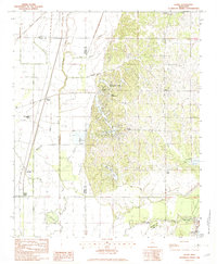
1982 Map of Banks
USGS Topo · Published 1982About this map
Banks and Eudora occupy the transitional landscape of northwestern Mississippi in the early 1980s, where the flat alluvial plains of the Delta meet the rising bluffs of the loess hills. This 1982 provisional edition illustrates a complex hydrological environment defined by the Coldwater River and the northern reaches of Lake Arkabutla. The map reveals a sharp contrast between the geometric agricultural drainage of the lowlands, marked by Beaverdam Bayou and Cormorant Bayou, and the winding, creek-carved terrain to the east.
Find a feature on this map
25 named features on this map. Tap any name to fly to it.
Don’t see what you’re looking for? This feature index may not catch every label — zoom into the map to look around manually.
Map Details
Editions of this 1982 Banks Map
2 editions found
Other maps of this area

1908 · Hollywood
USGS Topo · 1:24,000

1908 · Lake Cormorant
USGS Topo · 1:24,000

1912 · Lake Cormorant
USGS Topo · 1:31,680

1913 · Hollywood
USGS Topo · 1:31,680

1931 · Horseshoe Lake
USGS Topo · 1:62,500

1932 · Horn Lake
USGS Topo · 1:48,000

1932 · Crenshaw
USGS Topo · 1:62,500

1935 · Crenshaw
USGS Topo · 1:62,500

1935 · Horn Lake
USGS Topo · 1:62,500

1939 · Clayton
USGS Topo · 1:62,500