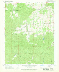
1968 Map of Banner
USGS Topo · Published 1969About this map
Pruitt Mountain and Logan Mountain dominate the topography of this Missouri landscape, which is heavily defined by the boundaries of the Clark National Forest. The settlement of Banner sits along Cedar Creek, serving as a central point in a region characterized by deep hollows and high ridges. The map reveals a community structured around its spiritual and family landmarks, including the Full Gospel Chapel and several burial grounds like Tullock Cem and Nelson Cem. Higher elevations are marked by the Bell Mountain Lookout Tower, which provides a vantage over the Kaolin and Arcadia townships. This 1960s survey captures the rural infrastructure of the era, from the Bellevue Valley Nursing Home to the network of drainage ways like Coon Hollow and Womble Hollow that feed into the larger creek systems.
Find a feature on this map
29 named features on this map. Tap any name to fly to it.
Don’t see what you’re looking for? This feature index may not catch every label — zoom into the map to look around manually.
Map Details
Editions of this 1968 Banner Map
2 editions found
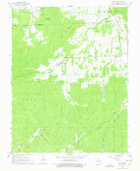
Other maps of this area

1905 · Bonneterre
USGS Topo · 1:62,500

1906 · Potosi
USGS Topo · 1:62,500

1924 · Edgehill
USGS Topo · 1:62,500

1926 · Edgehill
USGS Topo · 1:62,500

1937 · Ironton
USGS Topo · 1:48,000

1945 · Ironton
USGS Topo · 1:62,500

1946 · Ironton
USGS Topo · 1:62,500

1949 · Rolla
USGS Topo · 1:250,000

1953 · Ironton
USGS Topo · 1:62,500

1953 · Rolla
USGS Topo · 1:250,000