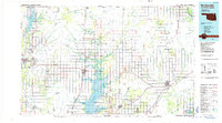
1985 Map of Bartlesville
USGS Topo · Published 1985About this map
Bartlesville serves as the western anchor for this expansive 1980s landscape, where the prairie of northeastern Oklahoma meets the edge of Kansas. The region is defined by the intersection of industrial activity and major river systems, notably the Verdigris River and Caney River. Significant aquatic features like Oologah Lake and the western reach of Grand Lake O' the Cherokees illustrate the era's managed water resources.
Find a feature on this map
76 named features on this map. Tap any name to fly to it.
Don’t see what you’re looking for? This feature index may not catch every label — zoom into the map to look around manually.
Map Details
Editions of this 1985 Bartlesville Map
2 editions found
Other maps of this area

1885 · Sedan
USGS Topo · 1:125,000

1886 · Joplin
USGS Topo · 1:125,000

1886 · Independence
USGS Topo · 1:125,000

1886 · Parsons
USGS Topo · 1:125,000

1889 · Sedan
USGS Topo · 1:125,000

1893 · Parsons
USGS Topo · 1:125,000

1894 · Independence
USGS Topo · 1:125,000

1894 · Joplin
USGS Topo · 1:125,000

1896 · Pryor
USGS Topo · 1:125,000

1899 · Siloam Springs
USGS Topo · 1:125,000