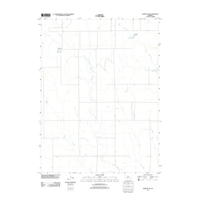
2011 Map of Bartley SW
USGS Topo · Published 2011About this map
Coon Creek meanders across this rural section of Red Willow County, defining the drainage patterns of an agricultural landscape north of the Republican River valley. This 2011 survey illustrates a region shaped by modern water management and conservation, characterized by a series of localized reservoirs and dams. The Kometscher Reservoir and its associated Kometscher Dam serve as central features in the northwest, while the eastern portion of the map is marked by the Dry Creek Reservoir 3-B and Dry Creek Reservoir 3-A. These smaller water bodies, alongside Wildcat Creek, provide a detailed look at the infrastructure required to manage prairie runoff. The grid of section roads, including 4th St and various County Roads, remains the primary structural element of the landscape, reflecting the enduring legacy of the Public Land Survey System in Nebraska.
Find a feature on this map
12 named features on this map. Tap any name to fly to it.
Don’t see what you’re looking for? This feature index may not catch every label — zoom into the map to look around manually.
Map Details
Editions of this 2011 Bartley SW Map
This is the sole edition of this map. No revisions or reprints were ever made.
Other maps of this area

1954 · McCook
USGS Topo · 1:250,000

1956 · Freedom
USGS Topo · 1:24,000

1956 · Quick NE
USGS Topo · 1:24,000

1956 · Bartley NW
USGS Topo · 1:24,000

1956 · Bartley
USGS Topo · 1:24,000

1957 · McCook
USGS Topo · 1:250,000

1957 · Danbury NE
USGS Topo · 1:24,000

1958 · McCook
USGS Topo · 1:250,000

1958 · Danbury NE
USGS Topo · 1:24,000
1958 · Indianola
USGS Topo · 1:24,000