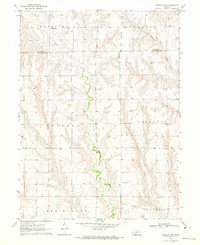
1970 Map of Bartley SW
USGS Topo · Published 1973About this map
Coon Creek and Wildcat Creek carve through the dissected plains of Red Willow County in this 1970 survey. The landscape is defined by the township boundaries of Harrison, Knowles, Fritsch, and Alliance, showing a rural Nebraska environment dominated by ranching and resource extraction. The map reveals a specific pattern of land use where isolated Wells and an Oil Well are scattered across the draws, indicating the importance of groundwater and petroleum to the local economy. Educational history is anchored by School No 42, a remnant of the early school district system that once served these remote sections. This sheet also traces the boundary between Frontier and Red Willow Counties, providing a clear record of property and political lines in the late twentieth century.
Find a feature on this map
15 named features on this map. Tap any name to fly to it.
Don’t see what you’re looking for? This feature index may not catch every label — zoom into the map to look around manually.
Map Details
Editions of this 1970 Bartley SW Map
This is the sole edition of this map. No revisions or reprints were ever made.
Other maps of this area

1954 · McCook
USGS Topo · 1:250,000

1956 · Freedom
USGS Topo · 1:24,000

1956 · Quick NE
USGS Topo · 1:24,000

1956 · Bartley NW
USGS Topo · 1:24,000

1956 · Bartley
USGS Topo · 1:24,000

1957 · McCook
USGS Topo · 1:250,000

1957 · Danbury NE
USGS Topo · 1:24,000

1958 · McCook
USGS Topo · 1:250,000

1958 · Danbury NE
USGS Topo · 1:24,000
1958 · Indianola
USGS Topo · 1:24,000