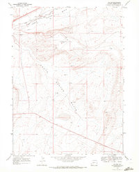
1968 Map of Baxter
USGS Topo · Published 1972About this map
North Baxter Basin and South Baxter Basin define this high-desert landscape in the late 1960s, showing a region deeply tied to energy extraction and transportation. The corridor of the Union Pacific railroad and Bitter Creek runs through the northern section, following a path long established by the historic Overland Trail. This convergence of historic wagon routes and modern rail highlights the area's role as a vital transit artery across the continental divide. Industrial development is evident through numerous gas wells and scattered drill holes across the basins, while the presence of the Rock Springs Airport and a prominent Radio Tower indicates the area's mid-century modernization as a regional hub for Sweetwater County.
Find a feature on this map
11 named features on this map. Tap any name to fly to it.
Don’t see what you’re looking for? This feature index may not catch every label — zoom into the map to look around manually.
Map Details
Editions of this 1968 Baxter Map
2 editions found
Other maps of this area

1908 · Rock Springs
USGS Topo · 1:62,500

1910 · Rock Springs
USGS Topo · 1:62,500

1954 · Rock Springs
USGS Topo · 1:250,000

1958 · Rock Springs
USGS Topo · 1:250,000

1962 · Rock Springs
USGS Topo · 1:250,000

1968 · North Baxter
USGS Topo · 1:24,000

1968 · Point Of Rocks SW
USGS Topo · 1:24,000
1968 · Rock Springs
USGS Topo · 1:24,000
1968 · Reliance
USGS Topo · 1:24,000

1968 · Camel Rock
USGS Topo · 1:24,000