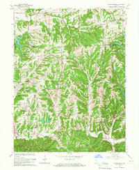
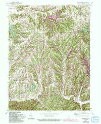
1962 Map of Beanblossom
USGS Topo · Published 1966About this map
The borderlands between Johnson and Brown Counties in the early 1960s are defined by a complex network of ridges and creek valleys, including Zion Hill and Bearwallow Hill. The settlement pattern follows the drainage of Beanblossom Creek and its tributaries, with small communities like Spearsville and Fruitdale serving as local hubs. This topography, marked by numerous hollows such as Cotton Hollow and Wolfpen Hollow, historically dictated the placement of rural institutions. Local landmarks like Sprunica School and several country churches, including Bethel Church and Mt Carmel Church, highlight the importance of community centers in this upland landscape. The emergence of recreation and residential expansion is evident in the presence of several reservoirs, including Lamb Lake, Sweetwater Lake, and Crestview Lake, which contrast with the traditional agricultural and timbered ridges of Hensley and Hamblen townships.
Find a feature on this map
47 named features on this map. Tap any name to fly to it.
Don’t see what you’re looking for? This feature index may not catch every label — zoom into the map to look around manually.
Map Details
Editions of this 1962 Beanblossom Map
5 editions found
Other maps of this area

1942 · Franklin
USGS Topo · 1:125,000

1946 · Belmont
USGS Topo · 1:24,000

1947 · Nashville
USGS Topo · 1:24,000

1947 · Franklin
USGS Topo · 1:62,500

1948 · Franklin
USGS Topo · 1:24,000

1948 · New Bellsville
USGS Topo · 1:24,000

1948 · Trafalgar
USGS Topo · 1:24,000

1948 · Nineveh
USGS Topo · 1:24,000

1948 · Fruitdale
USGS Topo · 1:24,000

1948 · Morgantown
USGS Topo · 1:24,000