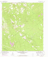
1958 Map of Bear Creek
USGS Topo · Published 1978About this map
The Sam Houston National Forest dominates this landscape along the border of San Jacinto and Montgomery counties. The area is characterized by a dense network of watercourses, including the East Fork San Jacinto River and its various tributaries like Winters Bayou and Jayhawker Creek. Settlement is sparse, with small communities like Magnolia and Oak Grove established near timber and water resources.
Find a feature on this map
35 named features on this map. Tap any name to fly to it.
Don’t see what you’re looking for? This feature index may not catch every label — zoom into the map to look around manually.
Map Details
Editions of this 1958 Bear Creek Map
3 editions found
Other maps of this area

1954 · Beaumont
USGS Topo · 1:250,000

1957 · Beaumont
USGS Topo · 1:250,000

1958 · Fostoria
USGS Topo · 1:24,000

1958 · Cleveland
USGS Topo · 1:24,000

1958 · Westcott
USGS Topo · 1:24,000

1958 · Bear Creek
USGS Topo · 1:24,000

1959 · Cut and Shoot
USGS Topo · 1:24,000

1959 · Conroe NE
USGS Topo · 1:24,000

1960 · Maynard
USGS Topo · 1:24,000

1960 · Camilla
USGS Topo · 1:24,000